Blog Image

AAA - triple & cube

Amazonas Antarctica Acongagua

Diary of a Grand Voyage

The World of Aruba

english Posted on 2011-03-11 09:59:06

Had the captain not said that we would be the only cruise ship in Aruba? Sure he had, and he had never misspoken yet on these matters. Yet, as we approached the dock, there it was: “The World”, a luxury cruise ship, nicely tied up along the biggest pier. The captain had been right though, things are not always what they look like in this world. “The World” was a cruise ship all right but, for the time being, it was turned into a hotel. Some say a room goes for five million dollars – ownership – and for that kind of money, it moves around the world from time to time too. It made me think of “The World” in Dubai – that wasn’t an island neither, rather a ill-conceived landfill with residential modules on top.

Docking was straightforward, cruise ships are welcome guests: welcome to the Kingdom of the Netherlands, not that Aruba is part of the Netherlands: that would be too easy. Aruba, together with the Netherlands, Saint-Maarten and Curacao belongs to the Dominion of Queen Beatrix. Understanding the world’s complexity, or its frivolity, is not simple, especially if you also consider that Aruba does not have the Euro as its official currency, but the “Florin”, referring to the old Dutch guilder. (Bonaire, formerly the B in the ABC islands chose independence but adopted the Euro).

And if that isn’t enough for fuzziness, here is a twister. Trying to be a nice cosmopolitan, as always, I had got some local money from an ATM in the terminal building. I went to a small shop to buy a cap, and found all articles priced in US Dollars. My cap cost $6 and I gave the attendant 25 Florins (approximately $14). As she started to dole out a few dollars in change, I asked her for some local coins. That she did not have! Two hours later, my taxi driver would react in the same way when I told him that he could keep the change, for a few local notes … no local money!

And all of this trans- and perspired under a heat leaden sky. Aruba is normally a kind of desert but it definitely sports a special climate. The average diurnal temperature is about 80F (27°C) but unlike in real desert conditions, the spread between day and night, irrespective of time of year, is maximally 20F (10°C). They had forecast “partially cloudy” today, but the meaning of that must have gotten lost in tropical calculus. In Belgium they arrive at such an estimate starting at “cloudy” and distracting, (it remains cloudy as a consequence). In Aruba they start from “sunny and clear” and add of few clouds into that. In any event, I was partially cooked!

The island is a paradise. More precisely, it is Eden if you are a beachcomber or a water rat. Barring its beautiful white sandy beaches and an ocean that varies between almost blue, blue, bluer and bluest, with touches of green and purple for good measure, there is next to nothing to see here, nor to do (I did not spend the night, but have not discovered places for night entertainment (Ron and Coca Cola on the Beach perhaps?).

Our brochure advertized the Natural Bridge, the California Lighthouse and the Casibari Rock formations as must-see. I decide to jump in a taxi and do some quick reconnaissance (because I also had to start planning the last laundry and the early packing). The taxi driver informed me that the 25ft high stone bridge had collapsed in2005. The Lighthouse was closed to the public two years ago, because it had been abused for jumping off. (He added that the suicidal people now just step in the waters off the East coast of the island, and the currents and surf do the rest). That leaves the rocks … they are also 25ft high and cannot collapse because they are lying on the ground! Nobody knows by whom, and why, how or when they were collocated in that little area. I climbed them and discovered their only obvious value: you had a clear 360° view of the grounds, all two hundred square miles of them, almost featureless.

Luckily the driver had a few ideas as well, saving my day and, of course, running up his take in the process. The Aruba Tree was the easy part to explore: it is a phenomenon alike to North Sea poplars, they are bent by the wind. In my neck of the woods the trees all, well, bent towards the East but they still standing erect. Not so in Aruba: as soon as they reach 10 feet, they continue to grow horizontally, invariably in a southwesterly direction.

The next stop was a cemetery. I have always found that cemeteries tell a lot about people’s customs and values – toilets, no intended relationship here, although nowadays also called restrooms – serve the same purpose, by the way, albeit in different dimensions. The Arubans rest together, all inthea family, so to speak. And they start under the ground (like most traditional burials) with the oldest “progenitors”. Their kids come on top, usually at ground level, and then they foresee one or two levels for next generations or siblings. In all we are talking about six to eight burial places, all from one family. I have not asked, but I wondered, especially since it was Ash Wednesday, how “returning to ash” works in a dry climate, three feet high?

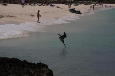
Finally he suggested that I should shoot a few pictures at Eagle Beach. He must have noticed, if only by my clothes, that I could not have many “aquaphile genes”, but he insisted that it would be worth my while. It was. Although there was not much curvy skin exposed under the unrelenting sun, the pelicans were out in full force – fishing. It was a grand spectacle of which I got a few good shots of happy pelicans!

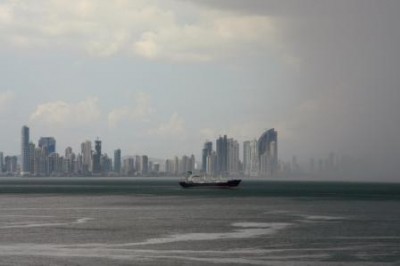
The afternoon was dedicated to training and packing. I say training because folding dress shirts, regular shirts, T-shirts and polo-shirts, in a way deemed acceptable when they arrive home, requires some practice. Meanwhile I noticed a continuous stream of big tankers moving East to West, and others West to East, along the horizon. I guess that it was oil from Chavez for his friends in Cuba. The world is a busy place indeed, also on the infinite oceans.

The coming days will be busy and radio-silent from my side. I will fly home on Saturday. Stay tune for a few reflections sometime next week! I hope that these stories have been as interesting for ye’all as the voyage has been for me.

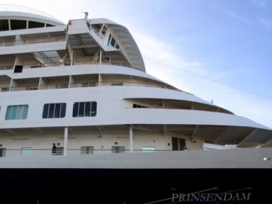
Prinsendam, Day 64 – Thursday March 10th, 2011

Getting ready for the last “All Ashore”


Panama, beyond the Canal

english Posted on 2011-03-09 03:51:58

Two days to go for Carnival, also in Panama. They are on a four day water throwing fest, de-inhibited by a liquid fest of sorts, beer being one of the sorts. The Prinsendam cannot dock in Panama City, as a matter of fact there are no commercial docking facilities. That would probably lead to a war anyway, with so many potential contenders for a limited number of piers. Then again, they are all in a hurry; as that was the raison-d’être of the canal in the first place.

I had signed up for a ride out to Indian territory. The canal, and the commerce that it has generated, has been overshadowing the other face of Panama: its pristine nature tracts. And to be sure, from our anchoring point, the skyscrapers of Panama City did not exactly provide any hint to the country’s real historical heritage either!

Yet, there are still seven indigenous tribes living in the rain forests of Panama, five in the East and two in the West. The readers, who like me, see Panama as split by the canal in North (Costa Rica) and South (Colombia) parts, better think of North as West and of South as East, as the Panamanians do. The trip started off with a bus ride of one hour, along a highway which was in a better state than the sound system on the bus. To make matters worse it looked as if the hearing impaired were sitting in the back, such that the front sitters started complaining when the guide turned up the decibels. Switching places would obviously have been an effective solution, were it not for the fact that the less mobile were also in the back of the bus …

We reached our destination without much more ado. The Indians hosts had come to meet us at the riverfront in traditional canoes. Although they were handcrafted they had left the paddles at home and used a powerful Suzuki outboard motor instead. Being narrow, relatively long and thus quite “mobile”, the boat balanced precariously around its longitudinal axis as it was being filled by the guests, many of them visibly unsure about their next step. Every boat took eighteen passengers, nine rows of two seats. Actually two “seats” was a one inch plank, across the full width, about one foot from the keel and probably three feet across at its widest. The embarkation was quite a spectacle to watch, judging by the many locals that had filled the landing area.

According to the brochure, we would reach the village after a thirty minute “glide” along the Rio Chagres. Not quite this time! To start with, the river turned out to give into a sizeable lake (many tens of square miles), which had been created when the canal was built (as drinking water reservoir). Its surface waters were not exactly flat either. Moreover, our “promoted paddler” ran out of gas, such that they had to organize a dynamic fill-up in the middle of the lake. It took almost an hour to reach the destination, but all in all a pleasant one! And time, well, time was not of the essence, not here and not then.

The village had organized a welcome party for the visitors on this Sunday morning: kids of all sizes, sexes and ages, a few young mothers and one older (wise?) man. All were dressed in traditional garb. In the case of the youngest kids that meant no garb. The novelty with this excursion was that it was organized by the Indians themselves: they made a conscious choice, in synch with the government, to complement their tribe’s income with tourism.

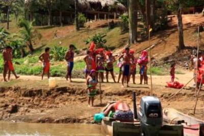
Nowhere was there any hint that they had (to) put up a show. We could see where they live, we could take pictures (not in the private dwellings), they explained (in Spanish) what they do and how they do it (a standard 20ft canoe is two months of hard work for seven able bodies), we could buy their artifacts of course, and nobody was begging. Although the villages of the Embera are isolated, allowing them to continue to adhere to culture and language, they are certainly not living in the wild. It was all relaxed, pleasant and instructive. I was lucky to bump into a resident (Greek) anthropologist as well; he explained how democratic and socially caring they all are where it comes to tribal affairs.

We spent about three hours in the village, including a tasty lunch of freshly broiled tilapia with plantain, served in a rolled-up palm leaf, followed by pine-apple and water melon. Imbibed with this new cultural experience, we returned to the canoes (easier loading this time around) and sped off to the other world.

As soon as we reached the lake we got a telling answer to an earlier question: why had we all received an “emergency poncho” when we boarded in the morning? A stiff breeze had developed over the Chagres “Lake” and hit us in full face, just to the right of the bow. Heaps of water spray was blown straight into us. Some passengers (which I had silently judged to be a touch over-cautious for eventual rain showers) had donned the cape before we had left, others had not. Even though I managed to hold the plastic more or less in front of me, I got thoroughly drenched.

It was Panamanian Carnival after all!

Prinsendam, Day 63 – Tuesday March 8th, 2011

On our way to the last (but one) “destination”


Diversity & Energy

english Posted on 2011-03-06 04:39:15

We are now battling the northeasterly trade winds, plowing north to Panama, with Ecuador fading away in the South. It is an interesting place, Ecuador: the land, its people, the economy, the society, as well as the air traffic control.

I mention the latter only because I had firsthand experience with it. Indeed, we flew from Manta, where we were docked, to Quito in the early morning; clockwork orange, in a brand new A319, with free snacks and coffee. The return flight was a different story though. Our flight was “in suspense” because the Control Tower in Manta had experienced catastrophic failure, whatever that may mean. Eventually, we were rerouted to the “old, small airport”. A 30-seat Dornier 328 propjet – my maiden flight – brought us back to the old and small airport just before scheduled sailing time.

That was the surprising end to a surprising day, for Ecuador (at least the little that I have seen and heard from it) is a unique place in many respects. For one thing, the land has beauty to offer to anyone’s preference and likings: from coast and beaches, to mountains and valleys, plus a stretch of vibrant jungle, it is there for the picking. Some of that jungle is virtually unexplored or intentionally left alone, for the Huaroani and related tribes, while another part is the engine for the country as it produces the black gold.

The other important diversity concerns the people. Ecuador “sports” around thirty different ethnicities. They derive from African, Indian and Spanish origin, mixed in various ways. In certain regions there is still a large original indigenous population, which, in their own right, is quite diverse, identifiable by language, physical environment and traditions, owing to the many natural barriers all over the country. I was told that in the province of Chimborazo, for example, one ethnically homogenous group is spread over thirty villages across the mountains, while they dress ostensibly different from place to place and maintain small linguistic peculiarities.

Quito is, of course, a little bit of melting pot. The many beautiful women walking on the streets testify to that as well. As far as I can tell, this city has the highest density of female beauty in South America. (Other observers confirmed this conclusion regarding beautiful men). It is a rather unique place: three million people, on a 2400m (8000ft+) high alpine plain, enclosed by two cordilleras, with a nearby towering and active volcano measuring almost 6000m (18000ft). But that is not all, Quito also has taken care of its historical architectural heritage, which is a jewel (and UNESCO protected).

Centerpiece of these buildings is the plethora of churches. Every important order of monks or nuns has built a temple in Quito, from the sixteenth century onward. The most spectacular church, flanked nowadays by the neo-classical building that is the Central Bank, is the baroque Jesuit Cathedral. While I have visited all kinds of churches during my global wanderings, I have never seen such an expensively decorated interior as in this place: on walls, pillars, altars and roofs you see gold hanging, standing and shining. Artfully sculpted or just richly applied, the yellow metal is everywhere. If any adventurer ever wondered where the “Gold of the Amazon” was hidden, he should have started here! Of course, they also built schools, for indeed, their main business was education.

The currency of Ecuador is the US Dollar. Ten years ago that looked like a great move to stop the runaway hyperinflation. And even today it finds broad support; to quote our guide: it was the appropriate way to prevent politicians from printing money and to make sure that all Ecuadorians, and not just politicians, had dollar denominated, inflation-protected bank accounts. This strategy is comparable to what Greece opted for in Europe, except that they still did not manage their budget (and were hiding deficits, of course). Part of the reason why this has worked in Ecuador is … black gold. The latter may also explain why new politicians started to talk about reverting back to a “national currency”.

Oil was found in the Amazon basin about ten years ago. It enriched not only the state, it also brought prosperity to the country, and especially to the oil workers during the boom of 2006-8. As their bonus was linked to company profits many made ten times their yearly salary in bonus payments for a few years. That luck did not befall tuna fishermen and coca workers but, because of the additional income, which the state in party redistributed, Ecuadorians enjoy free healthcare, education (including university), unemployment benefits and … subsidized gas. The latter explains undoubtedly why one sees many cars and a lot of late model cars, as well as real traffic jams, a sight unseen since Buenos Aires.

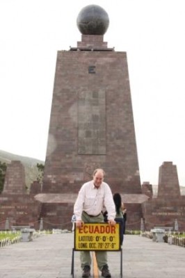
Of course, I also went to “La Mitad del Mundo”, the place at opposite ends of the continent from Macapà, in Brazil. Actually, it is here that (primarily) French scientist made the first exact scientific measurements about the earth’s equator. And, of course, I had my picture taken with one leg in the Northern and one in the Southern Hemisphere, simultaneously! The journey (journée) in Ecuador was a welcome reprieve from the choc of Peru: diversity and energy, both figuratively and literally. And there was lots of joy on the streets – Carnival is around the corner, as well!

Prinsendam, Day 60 – Saturday March 5rd, 2011

Ready for tackling the Panama Canal!


Patron Saint of Lost Causes

english Posted on 2011-03-04 04:17:08

Peru is a country of about five hundred thousand square miles (1.3m km²) and has just under thirty million inhabitants, one third of them residies in Lima, or around it (depending on where one cares to draw the city limits).

We docked in Callao, one of Lima’s forty-three districts and a busy port. It was six in the morning. The whole night the foghorn had been producing its basal noise, presumably with a frequency that was in some way proportional to the thickness of the fog – or the wakefulness of the bridge officers. (I bet it was the former).

The Humboldt Current, who causes this pea soup of sorts, glues the fog over thousands of miles to the coastline, stretching from well into Chile to the Southern shores of Ecuador (equivalent to a fog from Oslo to Lisbon, and potentially stretching all the way to Dublin in summer). Our guide would translate this in straight and simple English: Lima is a city where it never rains and where it is always foggy; therefore the sun shines “poco”. He added “unfortunately” to the statement, which would prove to be his favorite word during the entire day.

Three hundred years ago Lima must, in terms of architecture, have been a pearl of capital city. What is now called the “colonial town” holds the forlorn promise of class and riches. The classical Spanish baroque style is in abundant evidence, mimicking in every street something of the Plaza Mayor in Madrid, albeit embellished by the pure and varied palette of colors that reveal its profound “southern”-ness. The Plaza Mayor of Lima proper was occupied by hunger strikers, including their cardboard squats and babies to boost, who were demanding (at least) work. From closer range the buildings looked in obvious decline, and many in disrepair. That started in the eighties, and our guide added that the area was dangerous at night, unfortunately.

The neo-classical part of Lima is, in a less cozy but more monumental way, just as impressive. And it is well kept. That has everything to do with the simple fact that it is the place where the current powers hold office: the presidential palace, the mayoral palace, the “social club of Lima”, the cathedral and Episcopal Palace, the Franciscan Monastery, the headquarters of the banks, as well as related institutes and institutions. The parks, filled with perennial rainbows of blossoming flowers, give it all a relaxed and pleasant atmosphere.

It is safe too, a feature helped along by four kinds of police: the tourist police, the traffic police, the security guards and the military-like police. In front of the presidential palace that array of protection is further complemented by the ceremonial guards, as well as by Special Forces (with impressive firepower). Peruvians want to make sure that their President is truly safe, and this central square is appropriately called “Plaza de Armas”.

In terms of living comfort, Lima can actually be summarily categorized as four different cities. The smallest is the official Lima, described above. The second smallest is the rich Lima, occupying a nice stretch of ocean front, and sporting all the luxury hotels, designer stores, fine restaurants, .. all the modern works! Furthermore there is the poor Lima and the poorest Lima. I have no way of knowing which one of the latter is the “biggest” but surmise that the favela’s, hanging off the hillsides (much like in Rio) are tops in numbers. These numbers keep growing fast, naturally as well as through “immigration”, unfortunately. Noteworthy is that, in the poor Lima, the “less poor” (perhaps the well-off) secure their public streets at night by means of a steel gate.

The average annual GDP per head is five thousand dollars. (By the way, this compares with a salary of eight thousand dollars per month for one of Lima’s district mayors or any member of parliament). Thirty-six percent of Peruvians live below the (Peruvian) poverty line; twelve percent are labeled “extremely poor”. Estimates put the number of poor people in Lima province at 75%, unfortunately.

Effective health care is out of reach for most, certainly for those without a job, even if temporary! Even official burial can be a stretch. Education till sixteen is mandatory and, in the city proper, logistically possible, but higher education is, notwithstanding admission exams (the next ones are advertized country-wide on billboards for March 27th), only attainable for the rich (private universities, expensive) and for the well-connected (public schools, for free). The academically best students rarely make it to university, unfortunately.

Let me try and summarize the spirit of this country by what I witnessed at the Franciscan Church on Monday, February 28th. We had been visiting the 16th century Monastery, founded by the priest that accompanied Pizarro when he killed Atahualpa, the last Inca emperor, I believe. Exiting from the well-kept monastery, I entered the attached church where, surprisingly on a Monday morning at eleven, there was a mass in “full swing”. The church was filled with kneeling people in the center, and a spate of ostentatiously praying believers in the aisles.

It was very quiet though, as the Consecration was in progress. I stood still myself, in deference for all this devotion. After they prayed “Our Father” – in real Spanish, which was a reprieve from all the other deviating idioms that I had heard until now – they wished one another “peace”; this is one of the more recent, worldwide innovations in the rite. As I left the church, I could not avoid thinking that, where poverty reigns, keeping the peace must be a priority. (Remember Egypt?!)

Outside of the building a long, long queue of people had formed, stretching for hundreds of yards. They were mostly women and children, all holding bouquets of colorful flowers. Flowers are cheap in Lima, they grow everywhere. But why are all these people here, and on a Monday? I asked the guide. Well, he replied, on the 28th of every month there is a special mass in this church in honor of San Juan from Somewhere (I forgot from where). That man is the patron saint for the “Lost Causes”, for those that are at their wit’s end, in utter despair, unfortunately. Although I was utterly stunned, I understood the logic: if there is nothing else to hope for, one can always offer a few flowers to gain the favor of a saint, every month again or, perhaps, only once a month. And in October they celebrate the big mass, to thank the saint for all the good deeds. It comes across as cynical, and I think it is, just as our guide sounded, unfortunately.

To be sure, Charles Darwin tells, mutatis mutandis, by and large a similar story about Lima and Peru in his travels on the Beagle. Moreover, he visited the land just after the revolution and the independence, which are times, one would think, that are full of energy and optimism. If those were still present at all then, they definitely were canalized by the military, the landlords (fundadores) and the church in the ensuing and unending power struggles. Darwin described Peru as the most depressing country of the continent. I agree, so far.

If you add the recent history into the picture, Peru made the greatest strides towards daily normalcy (eradication of the gruesome Shining Path guerilla)and economic growth during the presidency of Fujimori, from 1990 till 2000. He was a democratically elected president (who, no doubt, intended to change the constitution to get elected for another term). Today he is in jail in Peru, charged with corruption, authoritarianism and human rights abuses. I cannot pass judgment on his alleged crimes but I am unequivocally convinced that there are no other “powers” (be they oligarchy, military or church) in this dirt poor country that are free of those same (capital) sins.

Peru is, in the end, a very cynical country, from top layers to bottom strata, albeit in different ways, unfortunately. With new presidential elections coming soon, I will have to hurry to re-read Vargas Llosa’s “El Pez en el Agua” to appreciate better what I have witnessed here during these three short days.

Prinsendam, Day 58 – Thursday March 3rd, 2011

En route to the northern hemisphere, after one more southern stop


Super rich, poor & poorer

english Posted on 2011-03-03 04:47:35

It would be an exaggeration to summarize a country of five hundred thousand square miles in those three words. Yet, not as flagrant as one might think, for in terms of human activity it comes close to describing the landscape, in full. Indeed, there are the fortified villas for the privileged, the cardboard and straw dwellings for the poorest, and some kind of housing for the poor, much closer to the cardboard than to the white concrete. The middle class and the simply rich (in Peruvian terms) do not really figure in the movie of daily life.

When we docked in Puerto General San Martin (the founder of the Chile Republic), I thought that Peru would have carried the spirit of its past. The foghorn had troubled my sleep for the better part of the night, which made me ill prepared for the Sunday journey to Tambo Colorado, the earliest Inca site that is still standing erect today (although without roofs). The port was a hole in the desert. I learned that it is used only for importing corn from the US and Canada, while simultaneously exporting raw salt for Northern winter roads. The salt is simply being scraped off the surrounding, barren mountains, as it is being deposited in sufficient amounts from ocean spray, carried by the very strong and daily afternoon winds.

If the port was a sober introduction to Peru, it was absolutely no match for the bus ride to Tambo Colorado, about 50 miles inland. From a geographical viewpoint this area (Pisco province) is situated at the Northern fringe of the famous Atacama desert, and it receives 1/10th of an inch (2 mm) of rain, annually. The other fact to mention is that this area suffered a 7.8 earthquake three years ago. With that in mind one knows that living conditions in this region are far from the usual.

And they absolutely were. Apart from the Nile Valley south of Cairo, I have never seen such squalid environment: shacks, streets (?), stores, you name it: in the villages as well as along country roads, dirt dominated the view. Perhaps because, and even from behind the shaded windows of our luxury bus, it was obvious that black eyes, with a stark darkness emanating from them, were, in fact, the most prominent and touching feature. In the absence of world TV cameras, and with no helpful and brave earthquake volunteers left, even the cleanup and the repairs had been abandoned, presumably for lack of funds.

Meandering though the last patches of road, still strewn with an unimaginable variety of garbage, we arrived at Tambo Colorado. With the desert to the West and South, and the Andes to the East, it benefits from the grandiose setting. It was touted, in the tour guides, as resembling Pompeii. Even injecting a lot of imagination, it is not: especially under the white light of the midday sun, you have to have good eyesight and be wide awake to discern the red, and especially the yellow wall paint (let alone paintings, or frescos!).

Still, our guide, one of the very few dynamic and engaged Peruvians that I have encountered in those three days (he hailed from Iquitos, in Amazonas though), made it a lively and interesting visit. He even personally demonstrated how the Inca’s were buried in fetal position such that they could easily be born again. Not only that, he vivified the offering of virgins on the altar of the grand square, in a way and with an enthusiasm, that we would not quickly forget.

The ride back to the new civilization was emotionally not more comforting: extreme poverty looks the same from all angles. We were on our way to what was listed as “the hacienda”, for a visit of the lands, the textiles and … for lunch. It was a one thousand acre (500ha) affair and we found it hermitically closed off from the surrounding world, not just for security but also for sanitary reasons. They had big tracts of asparagus, citrus (including the native “tangello”, from which a sweet white wine is made) and grapes. All of it, except the wine, was for export.

The lunch was a lavish affair, in a lovely villa with a pool, an abundance of flowers and trees, kicked off with some refreshing and finely-balanced Pisco Sour. Oh, I forget to mention the orchestra. We were served the cocktails and snacks by a few polite, but stern looking waiters. Even addressing them in Spanish did not bring some light to their eyes. Before we sat down for lunch, six young girls appeared in brightly colored long dresses to surprise us with African dances. It was obvious, and somewhat surprising to me, that all (but one perhaps) of the girls were black.

The host confirmed that there are still many black people in the area because of the slave populations in colonial times. I thought, wrongly, that the black slaves never made it past the Amazonas and Andes. When the lunch was finished the dancers invited guys from the visiting crowd and, being undoubtedly, at first sight, one of the more attractive dancers of the onlookers, I was invited by a boisterous and tall young lady. While the beat was unmistakably African, I just did the Chubby Checker moves, going through the knees and all, thus eliciting the general applause of the septuagenarians around us. It was fun.

Meanwhile I had been told that the host and owner was actually the Minister of Finance of Peru. He and his wife had started this hacienda twenty years ago and made it a green pearl in the surrounding desert (using water from the more or less seasonal Pisco River nearby). After next month’s elections he will be able to spend more time here again, I heard. The textile shop was actually an initiative of his wife. She had started a campaign, a long time ago, against domestic violence that culminated in gathering a number of women to make handicrafts, using traditional techniques. Today they number thirty-five, and produce beautiful artifacts (tapestry, handbags) in this otherwise desolate region.

If Pisco province was a decrepit place, Lima would not do much to change my impression of the country and its workings. If anything, Lima would paint a clearer picture of the barren social landscape that this democracy of sorts has spawned.

Prinsendam, Day 57 – Wednesday March 2nd, 2011

At what price proverbial “freedom” ?


A “Paradise Valley” of Sorts

english Posted on 2011-02-27 04:55:07

We arrived in Valparaiso at noon. “Paradise Valley” must have thought that it had to dress up for Carnival. The latter being so late in the year, it was a forgivable faux pas. Rather than at its colorful best, it seemed to be in a greyish mourning costume, as befits Good Friday, perhaps. This Valparaiso was a totally uninspiring sight, so that the many passengers that were not ready for the festive sail-in, weren’t really missing much.

For starters then, the short hop – still twenty hours, from Robinson Crusoe Island straight East to the mainland, pushed our second night in Antarctica out of the top spot in the hit chart of “worst seas”. It was a truly rocking affair, driven by the big swell from the West and supported by a cold, hard wind from the South. The latter meant that I could not open my door either. At four in the morning I woke up, sweating and with my stomach not in high spirits. After a really quick breath of fresh air, a little stomach pill and the intent to keep my seasickness record perfect, I went to sleep again. I do not remember any sweat dreams, but my record survived. From here on in, as we approach the tropics, this record should be safe all the way to Ft. Lauderdale.

Obviously, the sail-in at Valparaiso was nothing to write home about: grey, cool and, if you also consider the industrial port, not very inviting. I had no plans to visit the city (with 350K inhabitants, the second biggest in Chile), but I had opted for rodeo and wine in the countryside, topped off with some culture in the Viña del Mar, adjacent to Valparaiso but “chique”.

Just after noon we were heading for the Casablanca Valley, almost half way to Santiago. To be sure, there is not much charm in the surroundings. It resembles perhaps the San Fernando Valley in California, or the Corbières region in France. Our host turned out to be a big agricultural hacienda (I believe it is called “fundado” in Chile). Apart from vegetables and fruit, they were also into horses, Chilean horses. They resemble the Islanders in many respects, but, being a cross between Arabian and Castilian breeds, they are much more graciously built. If the Islander is a peasant, the Chilean is a nobleman.

The animals are purely bred for human pleasure, the biggest one being the national sport in Chile: rodeo. The “guaso” is to Chile what the more renowned “gaucho” is to Argentina, with the interesting detail that a guaso does not eat together with his horse, but normal foodstuffs instead. That doesn’t impair their phenomenal riding skills and equestrian prowess. I have not yet seen a sideways gallop at the same speed, developed within a short distance and closed out by a lightning stop, as I have enjoyed here.

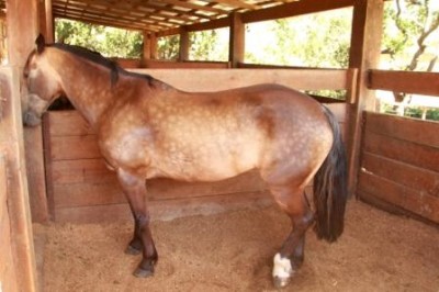
A girl of thirteen then, emphasizing how many lives revolve around horses, crawled between her horse’s front legs and hind legs, closing out her demonstration of trust between human and animal by inducting the horse to lay down, while she was sitting in the saddle. Quite a feat, I am told by people that know more about horses than I do. Rodeo is not only horses; it is also women, sorry – dancing. The Chilean “cueca” (national dance) is based on the rooster seducing the chicken. The only comment that I can make about it is that Belgian roosters do not waste all the time that Chilean roosters do, at least of the dance is a reliable rendition of the rooster’s behavior.

The Casablanca valley is also known for its wines. “To be known for” is always a relative qualification; I knew quite a few viticulture valleys in Chile, but Casablanca meant only White House or Humphrey Bogarts to me! Nevertheless, the domain looked attractive with, coincidence perhaps, a cozy “casa blanca” to boost. At the very least our tour of the facilities showed that investment (here by Italians) is continuing and the wine-making infrastructure can compete with the best and most modern in Europe. Whether the oenologists can, is a different matter altogether.

We tried three wines: Sauvignon Blanc, Chardonnay and Syrah. The vineyards at this (relatively) northerly location are better suited for whites than for reds because the climate is not really warm enough. While all the wines that we tasted were well-made, limpid and brilliant, I am disappointed by the pure “varietal” wines that are being produced. While the Sauvignon was acidic, with some notes of green grapefruit, the Syrah had lots of blackberry fruit but little structure. Both of these, and I am as much an oenologist as a horseman, would benefit, in my minds, by a few supporting grapes.

Then again, the wine industry, certainly in the New World is first business, before quality enters in the equation. Yesterday I took part in a Chilean wine tasting on the ship and was astounded by the baseless prejudice of the primarily American consumer, about single grapes as well as about price appreciation. It is obvious that a new winery cannot sell its product outside of the “single varietal” framework for the simple reason that the biggest markets will only buy varietals. They are often unaware of the fact that other products even exist.

Surely, Chateau Lafite and Mouton Rotschild can do as they please but Domain Casas del Bosque has no chance to establish its brand, no matter how great a sophisticated wine they would produce. In the end these wineries are condemned to compete on price and by varietal. Let me add that “Casas del Bosque” from Casablanca Valley makes very drinkable wine at the best prices that I have seen, since leaving Europe. Let me also add that I am utterly surprised at the margins that big distributors take on these wines in the States as well as in Europe.

I have added this digression because I am sure that many readers want to learn my (learned?) opinion about this matter. To cover all bases: compared to Brazilian, Uruguayan and Argentinean wines, the Chilean product is definitely superior in quality and in price! It would have been great to end the day here, but there was still a detour via Viña del Mar and the museum.

To make a long story short, Viña del Mar was celebrating the first day of their annual 5-day Music Festival and traffic as a mess. And, as befits such events, at every highest class hotel (a category of which the city sports quite a few) there was throngs of excited youths awaiting the appearance of their idols. By the time we arrived at the Fonck Museum, to be imbibed with Easter Island culture, I chose for fresh air instead …

Before returning to the ship, late in the evening, I still wanted to make arrangements for a journey to admire the Acongagua, the next day. That proved more difficult than I anticipated for two reasons. First, the mountain itself was not 100 miles (160km) away, as I had thought, but 150 miles (240km). That meant a three to four hour drive, all the way to Portillo on the Argentine border. The second reason was that there were few, if any, viewing spots at intermediate places; moreover the weather forecast was unfavorable, as well. After forty-five minutes of calling and investigating and weighing options, the advice was that I should consider foregoing the trip, unless … unless the weather forecast would be wrong.

Unfortunately it wasn’t. In the morning low clouds hung over Valparaiso. I checked the website of the Chilean Meteo and they predicted rain and clouds. Acongagua will not run away of course, and I will have to come back to see it! As we left Valparaiso at 1800 hours, I was able to shoot my first “sunny picture” in this – they say – charming city!

Prinsendam, Day 53 – Saturday Feb 26th, 2011

Ready for some desert! (i.e. a non-fattening, very dry place)

P.S. At the wine tasting on the ship, I found myself seated next to a lady from Pine Mountain, Halloway Gardens, Georgia. Many ISSers have visited or stayed at these (usually) lovely gardens more than once. What a small world!


Lake Robinson

english Posted on 2011-02-25 03:31:48

No, there is no Lake Robinson, at least, not as far as I know. This report is about the “Lake District” and ‘Robinson Crusoe Island”, but I better start with Crux. Observing the Southern Cross, on a starry, starry night, has been one of my (secondary) objectives. One may wonder why it had to take this long (48 nights …) to finally find and see alpha, beta, gamma, delta and epsilon in their red, orange, silver and blue dresses, marveling at the naked beauty of these heavenly bodies. To be sure, there were no forty eight nights to observe them, not even half of that number but, unless one explicitly decides, “now or never”, if it is a good viewing night, one often, if not always, postpones: I will do it tomorrow….

The dry air and the clear skies were still with us when we arrived in Puerto Montt, a sort of capital of the so-called Lake District. This region is still considered “Southern Chili”, as in sparsely populated and economically undeveloped. It groups a number of big blue lakes of volcanic origin, a few predominantly (central) European-settled towns and protected wilderness. From here to Santiago is a twelve hour drive, and to Punta Arenas there is a regular bus, thirty-five hours, up and down, on the East site of the Cordillera, via a route that straddles the border. The world as we know it, is still far away!

The guide started by telling us how lucky we really were. After all it rains 200 days per year for a total of 60in, or 1800mm. Living n the epicenter of the Western European Rain Dominions, I know that with those statistics, the chances for a blue sky day are slim indeed. As a matter of fact, the previous day they enjoyed an all-time record warm temperature, breaking the 1942 mark. The new one stands at 86*F/30°C.

The excursion took us a little north, and then east to the Argentinean border – Chile measures here, as in many places, less than 60 miles across. The lakes have been formed by volcanic activity. The first one, also the biggest in Chile, has an exquisite name that I cannot get stored in my long term memory. Measuring about 350 square miles, it is called “Lago Llanquihué”, with obvious Indian roots. My end point was another one, cozier and easier to remember: All Saints Lake (obviously no Indian roots). Nature has certainly done a great job at landscaping in this neck of the woods: snow-topped volcanoes (with all kinds of “tops”, including the blown-off variety), emerald lakes, all shades of green trees, lots of colorful flowers … while a matching infrastructure is still lacking, it is a pleasure for the eyes.

Driving past the various lake beaches on a summer Sunday afternoon, I was struck by the skin color of the locals: contrary to other parts of South America that I have visited so far, the general tendency was for pale skins. Indeed, I have seen a few real redheads, as they also sported authentic freckles! I have been told that very few Indians (Mapiche) survived the early colonization and that the area, from the coast all the way to the Lake Llanquihue, has been settled by Germans primarily. Traces of that influence could be seen in building styles and store names. I also detected a fire brigade truck that had “Feuerwehr” written across it!

Lastly, let me mention my first (and implicitly not my last) Pisco experience! No, Pisco has nothing in common with Cuzco, or any other Inca treasure, it is the national drink (also in Peru). The ship’s management had warned us though, in writing no less, about the dangers of consuming local Pisco. It wasn’t the “Pisco” itself (akin to Italian Grappa) that poses a direct health problem, although it is 100 Proof, but rather the other ingredients. The most critical is egg white and many a “mariner” had been taken ill over the years by spoiled eggs. We found a place, right in front of the gorgeous Volcan Isorno, (where they also sported an old German steam machine), with live chickens! Re-assured about the eggs, we indulged in a refreshingly potent and potently refreshing Pisco. Here comes the recipe:

Take eight parts of Pisco, four parts lime juice, three parts of syrup (the type defines the name of the Pisco, e.g. mango, green chilies, cinnamon & honey, avocado, mint, pineapple) and one raw egg white. Shake well with ice, strain in a glass. Salud! After our Pisco, we returned to the ship to promptly set sail for our next destination, seven hundred miles away, in the South Pacific.

Looking at maps of emptiness requires a special “setback switch”, for a ship is not a car and the scale plays games with our habits. The attraction “next door” is thirty-six hours away. Moreover, going west in the evening, and almost turn back on a dime, costs daylight hours. Nobody is counting of course, but the discrete changes in sunrise and sunset times, are substantial, raising an attentive eyebrow or two.

We arrived at Robinson Crusoe Island when it was still pitch dark. The sun was supposed to rise at 0810. We were anchored within shouting distance from the “capital” by 0730. Apparently the ship’s carpenters had to get to work on the pier infrastructure before we could safely get to land. There were no scheduled excursions; after all the place measured barely ten square miles.

This island, plus another two that constitute the Juan Fernandez archipelago, named after their Spanish discoverer (1574), saw its first (Swiss) settlers in 1877. The only noteworthy event of the intervening three hundred years was the “arrival” of Alexander Selkirk in 1704. He was dropped – at his request! – on the beach because he did not trust the seaworthiness, nor the captain’s skills of a ship en route to Peru. The ship sank a few months later off the Peruvian Coast and Alexander got plucked off the island by a rare passer-by in 1708, four years and four months after having chosen his new domicile.

Daniel Defoe, an erstwhile relatively obscure English writer, must have heard the story, presumably from Selkirk himself, and created the Robinson Crusoe bestseller. That is why, apart from romanticizing the adventure, some survival (and surviving) attributes of Robinson, alias Alexander, can be visited, most notably his cave and his outlook. The former is on a gently-sloping beach, just a few feet above the waterline. The latter is a saddle on the mountain ridge, 1800ft (600m) above sea level.

When I had been planning y walk the previous day, the idea was to set out for a three hour roundabout of the island, not unlike what I had done at Devil’s Island – it seems already an eternity ago. When the shuttle was ready to get us to shore, the sun was rising and the plan had to be shelved. San Juan Bautista, the only port and home for the six hundred inhabitants, resembled a huge stadium, hemmed in by steep walls on all sides. Any kind of walk had to be up, and then down again.

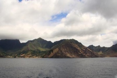
Rather than spending time in the tourist area with all the gift shops (imported from the mainland), I decided to go for gold: Alexander’s Lookout or “Mirador Selkirk”. The info board stated 2700m. Since that could not be the height, it had to be the length. After fifteen minutes uphill I had left the houses behind me, as well as all (imagined) competitors. Another fifteen minutes and my heartbeat was way up and my shirt started to change color. The first patch of rain forest had been traversed and, the path turned less steep. Another half a mile I detected a lookout point, a couple of hundred meters below the saddle.

By now, I had walked almost an hour and rain had set in (it would come and go four times in as many hours). Because my phone did not work and the going became more slippery, I decided to wait for the next pack of “climbers”. It soon became obvious that the pack would number zero, and I reluctantly turned back. I had enough excuses, the more important one that the ship would not wait if I did not make it back in time; nor would they have an easy way to figure out where I was… because the few birds that kept me company, were not of the messenger type.

After a rather tricky descent, straining the knees and calf muscles beyond what they have recently experienced, I arrived back in the village. The “spiny lobster catchers” appeared to be carrying much more Indian genes than what I had seen on the mainland thus far. To compensate for that, the island was full of Irish-colored dogs (no freckles though), in all sizes and shapes. They all had neckband but behaved like stray dogs (shared by the entire community perhaps?). They were quite friendly though and many visitors, including myself, were followed by one and the same dog, all the time until they left the pier – a live replica perhaps of Robinson’s guardian angel?!

Robinson Crusoe Island is, when you are in the neighborhood, worthy of a visit. In the summer it enjoys pleasant weather, with a sprinkling never far away. That explains the exquisite shades of green that cover the steep volcanic walls. The rock formations infiltrate the green tapestry with variations of yellow: from a whitish sand color, over ochre to orange yellow and igneous dark. It all makes that cruising around the island produces some remarkable pictures. And you can get a shot at Alexander’s cave as well!

Prinsendam, Day 51 – Thursday, Feb 24th, 2011

En route to Aconcagua


Fjords, Ragged Peaks & Glaciers

english Posted on 2011-02-22 03:23:21

The weather Gods took a day off, and so did the engines. That is the answer to the question that I left dangling, almost three days ago. After all, we had been well served “down south” (it translates for all my suspected readers, in their subconscious world vision, into “up north”).

Actually, and also because the Fjords did not create shareable joy and excitation, it deserves a minute or so to dwell on that subconscious world. If I am not mistaken, I have already indicated earlier on that each one of us has been raised with world maps that put us in the center of the earth. Consequently US printed maps are shocking to most Europeans because they are used to see Europe in the middle, and inversely. And all Northerners are shaking their heads when they are confronted with a projection that gives a closer rendition of true continental size: Africa bigger than Euope? Come on!.

By the same token, but less conspicuous, because it is somewhat out of the daily sphere is the rendition of North at the top, and South at the bottom of a chart that shows the earth’s circumsolar path. To be sure, astronomically or cosmologically there is no reason to have any preference. We have selected (subconsciously no doubt) to have North on top because the astronomers were Northerners and “top” is, presumably under the influence of Darwinian selection, always perceived as “better” than bottom.

Although I have been on the Southern hemisphere before, I have never had the opportunity to spend quality time (!) in it. Let me emphasize that a sun that turns backward in the sky, takes some getting used to. Indeed, the fact that you have to find it in the North at high noon is a little bit awkward. Luckily, it still rises in the East, and sets in the West… The exercise of imagining and thinking through Mercator maps that have the Southern Hemisphere at the top would be quite disorienting! Also, the psychological implications for the apparent “feelings of domination” in the Northern hemisphere would be worth researching – useful exercises in human relativity.

I will not digress into those inviting questions because they relate to other Grand Voyages, not to this one. I must say though that I was a little but surprised to find, after Ushuaia and Punta Arenas, that the sun was rising on MY side (of the ship), whereas I still expected it to set on my side. Subconscious knowledge needs double-checking at every turn, especially every 180° turn!

The Chilean Fjords are beautiful – lush, green, sculpted, wild, “encantador”. At least, that is what they say – and much more. That is also why I had decided to skip the alternative for an overland tour across the Andes, visiting the world famous National Park and the Torres del Paine.

The cruise through the fjords, along the southern ice fields, would be comparable to the “Darwin Cordillera” visit, along the Beagle Channel in Patagonia, but much bigger, much greener, much longer, … in a nutshell: the entire Grand Voyage Works! It was not.

Although we had left the metallic winds from Antarctic origins behind us – they were replaced by normal fifty degree, cool and moist laden westerly’s – the Weather Gods had left us behind as well! Shortly after leaving the Magellan Straits and turning north into the narrower waterways (the Smith Canal), the outlook worsened. Low hanging clouds and clammy rain had shrouded the upcoming spectacle behind a foggy curtain that would not lift all day long. It was a dreary day. That is why we exited the fjords in mid-afternoon, via the Golfo Trinidad, so that we could make better speed in the open ocean and take it easy the following morning.

Believe it or not, I was up again at six-something and … the promise of a glorious day announced itself on the eastern shores, thirty miles away. A naked, irregularly toothed, granite comb, hundreds of miles long, was bending – or so it seemed – the rays of the rising sun. Luck had joined us again, were it not for an inkling of trouble as the ship, during my early breakfast, slowed to a virtual standstill. Never mind, we soon continued our journey, followed by whales, albatross and many other flying creatures that I can admire but not name. Our path even got crossed by a few playful dolphin families.

It was one o’clock, when the captain announced that we had problems! Indeed, for a number of hours the ship had struggled with the cooling water intake as krill had accumulated in the water filters. We had come to a point where going into the narrow channels, with engines and boosters that could not produce maximum power on demand, was unsafe. Thus did we need to stop the engines to get everything cleaned out, before being able to continue. He could not estimate the time it would take, but we would not continue until it was all clean.

Obviously, the prospect for more fjords suffered another blow, because it was obvious that this was not an affair of a few hours. Surely, it was disappointing news. Then again, with yesterday a wash out, I had already concluded that I would have to come back and make it a round trip: overland and oversea, with enough spare time to wait out the weather. On the other hand, this unplanned “day at sea” was a gorgeous day. Lots of caressing sunshine, a warm oceanic freshness, an ongoing marine spectacle (although our “dancing with whales” must have contributed to the krilly setback), and … a white wine, a mojito, and a book (of course, what else?)

By seven, all that needed to be checked and repaired was checked and repaired, and the skipper announced our imminent re-departure. Instead of the planned “easy going, meandering route” (through the Darwin Canal) we needed to make up time and we would venture into the fjords a little bit more to the North. I cannot compare the route with the other alternatives, but sailing this last segment of the day, through the (wider) fjords, proved to be a gentle reminder of what we probably had missed. With the sun slow-diving into the open ocean behind us, we were witnesses to a water-and-light show, with the odd snow-covered mountain or volcano in the background. It was a pleasure for the senses.

Even though there was some compensation sailing through the last fjords in the dying light, I would have preferred the normal route (the so-called Magellan) through the fjords, past the ice fields and the glaciers of the famed “Campo de Hielo Sur” but we cannot instruct Nature to please us as we wish, luckily, for otherwise the ostentatious arrogance of 21st century (western) man (and woman – no discrimination here!) would culminate in speedy self destruction.

All in all, this was the last leg, the epilogue, of the second A and, notwithstanding the absence of the final and grandest string of glaciers, it has been an exhilarating adventure, the sensual (and where it concerns Antarctica also psychological) impact of which, one can only grasp if one has experienced it!

Prinsendam, Day 48 – Monday Feb 21st, 2011

After more than six weeks, I slowly but surely start to feel like a Robinson Crusoe


Patagonia

english Posted on 2011-02-19 03:08:46

Patagón means Big Foot. It is a name given by the Spanish, and not by the indigenous Indians. We seem to call every aboriginee in the Americas an Indian, as long as he does not live on the poles (then it is either an Eskimo or a penguin). If you ask me, perhaps, I tend to see Tierra del Fuego as the foot, with the toes, and the continent as a big fat leg.

Before we got there though, we had to make a big jump from the bottom up, from Anvers Island. The information panels on the ship showed us arriving at Cape Horn by Tuesday morning at eight. In my humble opinion that had to hogwash. To cover the 500 miles in eighteen hours we lacked engine power and extra propellers, not counting adverse conditions. In the Facebook and iPad era, thinking is no longer in fashion, such that, apart from the sloppiness of the cruise management, some were standing on the bow at seven thirty to get a good shot of Cape Hoorn, unfortunately still twelve hours away … Pretty soon we don’t need to have an April Fool’s Day anymore: we will celebrate it every day!

After all the rough seas in Antarctica, the Drake Passage was, if not a pleasant reprieve, a bit less punishing; but just a bit. The captain suggested that we were lucky: in his experience the conditions were “pretty good”. The sun was definitely shining and the horizon existed, visibly so. The clemency of the ocean was relative though, for the waves were about seven feet but the swell from the Pacific – the furious fifties – was estimated to be upwards of sixteen feet. Arithmetic – here I go again! – teaches us that the maximum waves will be twenty four feet, or more. And they were! Actually, every so often, spread anywhere between thirty and ninety seconds apart, we were hit by a “big long wave”: it pummels and lifts the ship from portside bow such that it shudders across its full length. Seaman’s legs were called for if you wanted to move about. We made it to Cape Horn by 1900hrs and, contrary to its usual garments – fog and rain – it was basking in the fading sunshine! Just splendid.

Ushuaia woke up under an open sky. And we were presented a picture postcard panorama with all the required ingredients. Less than an hour after docking, I was on my way to the Lumberjack Trail, an old logging route through the wilderness, in a 4×4. I can affirm that the all-terrain vehicle was an absolute necessity; never before have I been in a situation where all the features of a sturdy jeep have been tested as thoroughly as in this “raid”. In Tierra del Fuego, that is what you need to have, if you want to sight beavers and red foxes … and to gain access to the crisp beauty of the highest alps and valleys.

Our guide made this tour an indelible success, thanks to his in-depth knowledge of nature, his passionate talking, his excellent English and his remarkable driving skills. One of the interesting stories that he told us, concerns the beavers, which are not indigenous to the island. About fifty years ago, English fur dealers started breading Canadian beavers in captivity. However, because of the climate, these animals “adapted”, and the thickness of their hives decreased by more than half. Uneconomical, the business was abandoned and the beavers … set free. Initially they were kept in check by the red foxes, but these got almost hunted to extinction (also for hives). The beaver community flourished!

To stop their expansion – their dams caused a lot of damage to the trees of the primary forests (predominantly “lenga”, local beech species). Therefore it was decided to import “grey foxes” from Southern Patagonia. The decision had been taken hastily and produced unintended effects. First, the biggest beavers had become too strong for the grey foxes, who are supposed to be natural beaver predators, to kill. Secondly, and overlooked but critically important, the grey foxes are plain dwellers. They did not at all like the mountainous terrain of the Southern tip! As a consequence, they “shut their shop and moved”, almost immediately, towards the North side, where they attacked the sheep in the many farms! The last episode, for now, is that the government pays beaver trappers 25 pesos (US$ 6) per tail, which is apparently too little to attract enough “bounty hunters” to tackle this serious problem, while the forests suffer more with each passing day.

The “talk of Ushuaia” concerned not beavers though, but rather octopus. I should say the “Octopus”. Indeed, this gorgeous deep-blue yacht was moored in the harbor, opposite from the Prinsendam. Our guide told us that it belonged to Paul Allen, adding, you know, “the Paul Allen from Microsoft”. It is still supposed to sail for Antarctica one of these days, or weeks, they say. Apparently, two weeks ago, Paul Allen and Cameron Diaz had landed (with a private plane) at the international airport, about ten kilometers out of town. While I have not seen any traffic jams anywhere around Ushuaia, a helicopter – part of the yacht’s regular operations – was readied to take off from the Octopus’ helipad, situated on the stern. Seconds after lift-off, in very strong winds, the helicopter stalled, crashed into the water, and sank. The pilot was saved and the machine was hoisted out of the water by a big crane the day afterwards. Paul & Cameron got on board by means of another helicopter, which had hastily been chartered. How they passed their time afterwards had not been communicated … to the locals.

With that unexpected touristic “encore” – Octopus is a pearl; it permanently sports also a helicopter and a mini submarine (visible in the back of the helipad) – we set sail for the continent, through the Beagle Channel, and past the Cordillera Darwin. The weather gods were protecting us, and Mother Nature complied by dishing up exquisite panoramas, filled with granite peaks, steely glaciers, waterfalls, forest, peat moss, little inlets and fjords … Darwin and Fitz Roy must have marveled, for hundred and sixty years ago, it undoubtedly must have more brilliant still. Our cruise-by was commented by an expert, so that I was busy for four hours, running in and out of my cabin, taking many pictures, all part of the “Oooh” and ”Woow” and “Geee” species, or genus, as the case may be. I need not explain that it was breath taking, both literally and figuratively.

The Patagonian adventure was supposed to get an extension on the mainland, in Punta Arenas. That would be the start of our ten day visit to the most extreme “length-over-width” country on earth. The early encounter, at seven in the morning, was sobering. Compared to Ushuaia this port city was not a pretty sight. We could have guessed, because, apart from the southern part of “Fireland”, all of Patagonia is essential flat, and arid.

Punta Arenas was surrounded by a few gently rolling hills, the highest reaching 600m or 2000ft. In front of the hills the Straits of Magellan measures fifteen miles wide, and beyond these hills flatness reigns supreme. Rather than visiting penguin colonies, sheep farms, old colonial forts or once-booming haciendas, I had decided, uncharacteristically, to go for a walk – from the top of the highest hill, through the primary “lenga” forest to the foot of … the chairlift! And what a chairlift it was. Last time I saw a similar contraption was in 1973, in a little alpine village in Switzerland – when skiing was just a pass-time, not a business.

The chairlift did not instill a lot of confidence, not even after one of the machinists demonstrated that one (at least) had survived a ride to the top. In the end, the greatest challenge was the wind. Wind is ubiquitous in these areas, and it is a very particular flow: it smells and tastes metallic, it seemingly cuts its way through clothes, as well. On the other hand, it carries with it an intense and fresh purity. I guess that the best way to describe it is to christen it as a “platinum wind”, very cool and crisp, yet very noble.

The walk was wonderful, primarily because, as is the case with many facets of nature down here, it is unique. I have never walked through a forest like it. The tortured beech trees are showing their different wounds – bent, cut or sliced, by cold, rain and wind. The open roof – i.e. the absence of a canopy, and the varied undergrowth, give it all an inviting, sun-lit atmosphere.. “Deedeleedee”, indigenous blueberries and mushberries (fungi actually, but staple food for the aboriginal Indians) were ripe and inviting to be picked. All in all, another feast for the senses.

To conclude, and since Punta Arenas itself has little else that is worthwhile to mention, I ought to report our encounter with an old, and abandoned coal mine. Indeed, as we were descending a slippery, somewhat steep and circuitous path in the forest, we ended up at a hole, filled to the brim with black water. The ventilation duct – for that is what we had stumbled onto – was squared off: four sturdy round poles at the corners, and twee lateral planks, about 4 inches wide, one at chest height, and the other a couple of feet above the ground.

If the guide would not have told us what was in front of us – a waterlogged pit of fifty meters (one hundred and sixty feet) deep, we would not have had a clue (the old mine entrance was further down the path). No information board, warning or danger sign, nothing, apart from the silent wooden enclosure. Perhaps it shows that these places are still “wilderness”, places where you venture at your own risk. What made it all the more remarkable to me was that, on my daily extract of the New York Times, the headline read: A Life’s Value May Depend on Agency”. The article went on to explain how different agencies “calculate” the value of a human life. In 2008 that value averaged about five million dollars and today the number has increased to almost eight million, and mounting. In the South of Chili they obviously are not thinking off the same sheet. Maybe they do not think about it at all. A philosopher would wonder why.

Prinsendam, Day 44 – Thursday Feb 17th, 2011

Coming up: two days of cruising through the fjords. Will the Weather Gods continue loving us?


Antarctica

english Posted on 2011-02-17 04:25:36

I think it is fair to say that we were not really ready for the cold, the biting cold, pervasive and persistent. And it wasn’t even freezing, at least not during the daytime. Everyone had brought warm(er)clothes but probably many, if not all, forgot to pack also a new mindset. Overall I believe that we had been somewhat naïve about the essence of this place: it is a hostile land even though it offers fairy views.

From the Falklands we sprinted for 600 miles to arrive at five in the nascent morning at far eastern end of Elephant Island. It may not ring many bells but this island was a witness to one of the greatest polar heroics of the early explorers. Twenty-five daring guys got stranded, the boat destroyed and Ernest Shackleton, the expedition leader, used a lifeboat and five men to row to South Georgia, 500 miles away, and returned, five months later, to save the others. We were lucky as we caught the place as the sun rose, and shone on rock and ice. A few sizeable icebergs emerged from the shadows, while ice and rock created idyllic images. The viewing conditions even allowed us to see the imposing Endurance Glacier across ten mile “mouth”.

Because we had an appointment with “real big icebergs” on the inside of the Antarctic Peninsula, we turned South after an hour for the next race. The following days icebergs would always be somewhere around us, sometimes pretty looking, at other times nasty. The spouts of accompanying whales kept me busier than the icebergs, changeable weather permitting. We entered the Antarctic Sound (at the very tip of the trunk, which is called Graham Land) just after noon. Once again the weather cooperated, the sun was everywhere.

Describing the visual and auditory experience that Antarctica offers, is a challenge that I have no intention of taking on. Even though they say that one picture is worth a thousand words, a thousand pictures cannot commence to convey Antarctica, not even the little patch that I would be visiting. In the end it is this enormous variety of physical and biological creation, which hits you continuously right up in your face, that makes the Antarctic wilderness into the grandiose attraction that it really is.

In the Sound we found gigantic icebergs, many tens of square miles apiece that were broken off the Ice shelve, floating gently but purposefully out to sea, We also discovered young penguins enjoying the sun basking and deep diving around floating ice SCHOTS, while their parents are still molting on the shores. And birds, and seals, and sea lions, and hanging glaciers and land glaciers, and people – in bases, and birds, and, and …

One thing we learned about penguins is that you always know when they are coming or going. Indeed when they are coming towards you, they always look white, when they are going they turn pitch black. That colorful black and white show is very evident when the seals or sea-lions are lurking, usually looking disinterested, in the neighborhood. We ended up all the way down to Esperanza Bay, which has been settled by Argentina. Settled is the right word because the first Antarctic (human) baby was born here on the 7th of January in 1978 and this base hosts families only.

From Antarctic Sound we sped up North again to Deception Island. By the time we arrived, just before sunset, the skies had clouded up and we were left to consume only the deception. Under cover of night, we steamed up to “my” area: the Belgian archipelago. That is not really what it is called officially but Belgian cities, provinces and explorers have given their name to many island, bays and straits.

The primary causes for this surprising state of affairs were the polar expeditions of Adrien de Gerlache, a noble and rich son of the city of Antwerp, in the late 19th century. Early in the morning we passed Brabant Island and then went on to Anvers Island; Anvers is the French name for Antwerp. (Until the end of the 20th century many “rich people” in the city spoke French, rather than Flemish, at home as well as in the executive rooms).

The idea today was to actually navigate the “Gerlache Straits” and visit a few picturesque bays that were strewn along the way. The weather would do its very best to show all its colors, except for full blue! Still Culverville Bay and Paradise Bay were pearls in the gallery of natural polar sculptures, even with nebulosity setting in. Although wonderful, it must be mentioned that icebergs in the narrow straits or in glacier-walled bays, project a different posture than they do in the open sea. It is definitely crowded at times, and deciding when to turn and how to turn a big ship requires careful observation, by ice watchers on the bridge, and, I am sure, excellent sonar equipment.

By early afternoon the wind suddenly picked up and we made out to the Bismarck Strait. That is a relatively wide thoroughfare along the southern shores of Anvers Island, albeit not free of drifting ice, in all shapes and sizes. After gusting up to 60kts, mixing in some snow for good measure, the icy, bone-chilling wind died down. But by then the bridge had decided to call it a day, as far as sightseeing was concerned. That would prove to have been a wise decision.

Indeed by six, full afternoon so to speak, we got a replay. Actually it was much worse. By dinner time we had escaped to the open ocean, where the waves averaged a very uncomfortable 15 to 20 feet, but where ice was no threat. Many tables were not as occupied as on an average night. The ferocious storm, the barometer had meanwhile plunged to 960mb, would take the foot off the throttle by three in the morning, just in time to catch a little bit of sleep before hitting “the Antarctic Road” again.

Our next target was Palmer Station, where we would pick up American researchers who would present on the ship about their work at the base, and then we continued down to the famous Lemaire Channel. (Lemaire, explorer in the Congo, was a friend of Gerlache). The weather improved very much in a very short time, typical Antarctic variability. And it would stay relatively sunny, with haze and little wind, until we would leave for our return to a hospitable world.

The scenery in this channel is breath taking and, on a good day, it is passable from North to South over its entire 7 mile length. At its narrowest point it is about one mile wide, and usually clogged with ice. I was actually surprised by the size of the icebergs that came out of the whited granite hole! And, pushed by a current estimated at 4 to 5kts, they were awe inspiring. Unfortunately our captain could not discover a safe way through the ice, and we turned around, to go and visit the alternative site, named Neumayer Bay (and Channel) where a British station, surrounded by loads of Gettoo penguins (and their predators, of course). Here again, with the sun illuminating the snow covered granite spires, there was no lack of the magic images that we had encountered all over the place, visibility allowing.

Apart from discovering this “extra-ordinary virginal environment, the US delegation brought us up to speed with some of the research that they conduct. With a summer occupation of 36 persons (and 16 in winter) Palmer is the smallest of three US bases in Antarctica. McMurdo, about 300 miles away, houses 1100 staff in the summer, and is the biggest station on Antarctic “soil”. The Palmer scientists focus on biology, in particular on the food chain, from mammalians all the way to the smallest plants. They have discovered viral beings that actually help plants to survive in the freezing waters, and have actively studied the “Icefish”. That is very outlandish species, and is unique in terms of blood color: it is white, because it lacks hemoglobin. The challenge is to figure out how the entire metabolism (oxygen transport) works.

As we left Palmer to go North again, I came to realize that no pictures no explanations can convey the immensity of this continent, because, in the end, they cannot convey the simultaneousness of all the elements that make Antarctica absolutely unique. You have to come here and undergo the influences of this beautiful and hostile environment.

Prinsendam, Day 41 – Monday Feb 14th, 2011

Swell and waves will be on our side while sailing to Tierra del Fuego, Fireland!


Falklands

english Posted on 2011-02-13 03:02:01

The internet connection, which has required skilful monitoring in order for the user to avoid getting overly frustrated, has now been declared defunct, for as long as we are around the pole. That is due to the fact that the earth is round, says the company – for now. I knew we were all going to get a little bit smarter around Antarctica, but most certainly hope that we all can still improve on this one!

Upon leaving Buenos Aires, where some passengers left and new ones joined us, a few pawns were moved on the dining room chessboards. As one of our tablemates had departed, we had the pleasure of greeting a type of American that we had been able to avoid until now: a New Yorker. He was the in-your-face type, which is normal because there are no others among the “born and raised in NY” specimens, also if they were born more than eighty years ago. All told, and taking an hour or so to get used to the style, tabular peace overtook the reserved politeness that had clouded the early conversation: he is a nice and interesting “bloke”. And a teacher, who listens more than he talks, as well.

The sea days between the Plate estuary and the Falklands were very lookalikes. As the sun rose, a little earlier every day as we moved south relentlessly, it was cloudy, rainy, foggy, dreary for short. By midday though, the sun had found its way back to the decks and, as long as one had shelter against the wind, it was a meteorological dream world. The ocean was flat as a lake and the swell had, miraculously (?), disappeared, as the strong morning breeze had been turned into a subtle sigh. As the bow cut softly through the rolling wavelets, the splashy liquids provided the background rhythm for humming a dreamy melody. Actually, the melody was turned into a symphony, long enough to paint me red!

The sunburn would not pose any problem, because my skin would get a well-deserved rest. Indeed, the weather for the Falklands read: 11°C (54F) and mostly overcast. Not only was it cool, it was also pretty windy. According to the Cruise Director – the Entertainment Captain so to speak – there were no other skippers capable to get this ship in these waters under these conditions for anchor – outside of our very own Viking. We found ourselves about three miles out of Port Stanley, girded around a distant bay, looking colorless, thanks to the fog. The “tender operations” were announced as challenging and everyone would have to show understanding and patience. As time is not an issue on for the folks on this voyage, patience was available!

Why anyone had ever gone to war for these islands – no oil, no minerals, and no agriculture – is quite puzzling. With its five thousand miles and three thousand inhabitants, it is a rock formation that jots out above the Atlantic by sheer accident. That was also obvious to a substantial number of penguins, and they have made it their home in the summer to mate, to hatch and to molt, before going back to sea – to live! Obviously English and Argentines thought they knew things that the penguins did not, or did they?

We had come to see the penguins, and I had chosen to visit the Gentoo en the King species, two of the four visiting and summer-resident breeds (there are also Magellanics and Rockhoppers). The interior of Iceland is somewhat similar to the Falklands but much more “civilized”. Here there are no beaten tracks, only beaten bush and you need Indians to show you the way. After a boat transfer of fifteen minutes, we boarded two Land Rover Defenders that brought our party of twelve to Sparrow Cove, our destination. Along the way we passed minefields (not a tourist attraction), and pearl white beaches with clear, turquoise water, across slow hills and long valleys, covered with all kinds of grasses and weeds (with impressive names). After half an hour we arrived at a verdant atrium-like slope, between two rocky outcrops, perhaps five miles apart. They were slowly dipping into a silvery ocean. And there, at last, we discerned the colonial occupants that we were looking for, many thousands of them!

They had starting mating and hatching by the end of September. Most of the newborn were already trotting around; some were ready for their maiden dive, others had to lose a little bit more chick-y down. Ostensibly that was a task for the ubiquitous wind. Countless carcasses were littering the grounds too, varying between just deceased to bone-picked. Apparently penguins are conversant with Darwin: parents decide amongst themselves which from their two chicks will be most likely to survive, and they just let the weakest wither in the wind, literally and figuratively.

These sixty day old Gettoos are funny folks, and very curious. They walked up close to us quacking, gaggling and sniffing, not afraid at all. In the coming weeks the dad and mum would teach them how to swim and dive and then … they had to look after themselves, alone. They live in large communities but there is no small, cozy family. It obviously has nothing in common with the European perennial care and welfare society.

When I was returned to the port proper, two tenders were tied up at the pier. That was strange because these horses are supposed to shuttle. Upon inquiry I found out that the tender operation was suspended, until further notice. The wind had “picked up” to 55 knots, 62mph or 100km/h: gale force. Rather than wait around the terminal and join the chatter about the length of the suspension, I decided to meander through the city.

The walk took time and energy; that is due to the fact that the city is stretched over a couple of miles along the bay, about ten terraces high if you want to see the “Stanley circular road”. Everybody has a historic building in his neighborhood, as they are all spread across the hill. This capital village of 2000 souls, most Anglican and some catholic measured by the size of the churches, sports a hotel, a post office with a “philatelic branch”, two churches, a museum, one cemetery … in the end, there is nothing out of the ordinary, lest we also mention the British expeditionary legion numbering 1500 young soldiers.

After two hours, the wind had taken back some of its gas and they had decided to give the transfer operation another try. The biggest challenge, apparently, was docking with the mother ship. Eighty willing, able and impatient men and women had found a spot in those tin boxes, without a keel, which we call “tenders”. More experienced hands than I suggested that these boats might actually flip over, if the weather was not cooperative! I figured that the heavier the load, the lower would be the risk. Eighty was a good number!

My reputation as a jockey and as a sailor is a closely guarded secret. That is because nobody has ever been able to catch me on a horse, or on a sailboat. Leaving Port Stanley I can honestly claim that I have been on both. Although I don’t think that the three mile ride to the Prinsendam was dangerous, it was definitely as adventuresome as a bucking a colt. Add to it all that the water rushed into the boat with every gale that hit us, as we came perpendicular to the direction of the waves: fun for some, misery for others. In these moments you also realize that the tender sports a lot more gaps, slits and holes than you ever thought possible! We made it, safe and sound, of course. This is an expeditionary voyage after all.

The Antarctic, another extraordinary port of call, is next. We are ready for the adventure, but are we ready for the cold?

Prinsendam, Day 38 – Friday Feb 11th, 2011

Steaming towards Elephant Island


North & South of the Plata

english Posted on 2011-02-09 03:34:51

Rio de la Plata, Silver River, but there was no shiny Plata at all, never has been. As a matter of fact, the rio looks as muddyish as the Amazon. That is not abnormal, for it carries sediments down from similar highlands through similar lowlands into the Atlantic. This 160 mile long estuary is, in essence, not “big”. It definitely is among the world’s largest in surface, but it disappoints in volume, for it is very shallow, with only a very narrow navigable channel.

On its North side there are rolling hills, infinite beaches and blue rivulets that empty, and disappear, in the brown Rio de la Plata. On the South side stretches Argentina, for thousands of miles, pampas, all the way into Patagonia and halted in the West by the Andes wall. Judging by their capitals, and surroundings, Uruguayan and Argentine society are, surprisingly, different.

Starting with a local monument: there is no argument about the tango, the shared national dance. Both Montevideo and Buenos Aires agree that they represent, and still are, the cradle of tango. We wouldn’t be “homo sapiens” if we would have agreed to have one and only one tango for neighboring cities though. Conoisseurs posit that Urugayan and Argentinean versions are different. I have watched both versions and was, understandably, unable to discern those differences. That means that the similarities must have dominated. One of those similarities is that the female partner, regularly and energetically, kicks, swings and turns (all simultaneously) her sharp heels up – between the legs of the male partner. Surely, as a young man, you must put a lot of trust in the proficiency of your dance mate! I suggest that one never dance the tango with his wife in the midst of a running argument … (Chances are that most of us won’t get hurt, because the dance probably takes us a lifetime to learn and by then energy decreased and harmony, presumably, increased ).

Romantics claim that Montevideo has been so named because a sailor on Magelhães’ ship (1520) saw the little hill and yelled out “Monte vidi eu”. Not perfect Portuguese it seems, and not likely neither, because the city was founded two hundred years later. The historians, having their own variety of romanticism, bring it all back to a bean counting cartographer who wrote down: MONTE VI DEO. This supposedly meant Hill no. 6, Del Este al Oeste. I did not watch the passing hills but reliable sources say that the little butt, west of the city, is indeed still the sixth, counting from the entrance of the Plata estuary.

Uruguay has 3.3 million inhabitants, 40% of which live in the capital. Apart from a huge baroque parliament building – always a symbol for flourishing democracy, which often exists only symbolically as well – and a few well preserved temples, such as the opera in downtown and the Centennial Stadium on the outskirts (where Uruguay won the very first World Cup in 1930), the city has little to get excited about. The commercial downtown area measures a few square miles and projects the image of a medium size regional city in Spain or Portugal (such as Bilbao, or Oporto). Leaving the center, even the erstwhile beautiful neo-classical patrician houses immediately offer a depressing view, interspersed by low and simple houses, downtrodden and dark. People obviously are not well off, an observation that gains in veracity as you move farther from the center. It appeared to me that Uruguay was a society with little or no middle class, and with few, if any, ways and means to create such a middle class.

The countryside is equally unimpressive, not to say outright boring: shallowly rolling hills, relatively green pasture and bush, with little or no movement. I was told that it hides 6 million heads of cattle and double that amount of sheep. More towards the North the land gets hillier and shadier, and at its extreme Western side it offers great Atlantic sandy beaches, culminating in rich and prosperous Punta del Este. That resort is also a magnet for rich Porteños (=inhabitants of Buenos Aires), who bought second or third residences on that side of the river.

Personally, I could not resist the temptation to visit a local winery. In a flat land, relatively hot in the summer (it was 30°C/86F), relatively little rain, suffering from frequent and substantial southerly winds, one adjusts his expectations. Basically Uruguay makes primarily red wine, from primarily indigenous grapes. Indigenous means that they are Italian or French varieties that have been crossed with local vines, to better withstand the climate. Most of the wine is made from “Tanat”. It is an acceptable table wine for a summer BBQ. We also drank a white chardonnay-viognier which was refreshing (after 90 minutes on a bus) but showed little other characteristics. Most surprising of all was the price they were asking: $9 for the cheapest bottle and $800 for a bottle “Port-like” wine from 1992. For that price one may probably still be able find a bottle of 1970 Vintage Port ..outside of Uruguay

Continuing on the wine trail, I also visited a wine merchant and cellar in Buenos Aires. Argentinean wines are, in Europe, less invisible than their northern neighbors, especially the so called “national pride”, malbec, is easy to find. Here I tasted an espumante, a white from high up the Andes, and three Mendoza reds (Bonarda, Syrah and Malbec). The “Méthode Champenoise” bubbly liquid was quite indistinct, and it would not beat most traditional European competitors, certainly not the likes of Cava, Prosecco or many other well made bubblies. Yet, they were asking $19 for a bottle. The other two local grapes (claimed to be varietals from Toscana) did not impress nose nor palate. The syrah was good enough and the malbec was, in my humble opinion, a balanced, round and pleasant red wine (with broiled red meat, preferably). However the price of a 2006 Malbec was … $45. At those prices I think that Argentinean premium and export wines will remain “small business” for many years to come.

Buenos Aires is, without a doubt, one of the world’s top capitals. What it lacks in natural beauty, compared to Rio, it makes up in architectural grandeur. Where the people and the state found, and find the money to build and maintain all the splendor, has remained a secret for me. Not only does the city boast magnificent buildings from the 19th and 20th centuries, including a subway dating back to 1913, they are renovating old neighborhoods in styles resembling the best projects in Europe. Obviously, the middle class is growing in Buenos Aires, and there is optimism in the air, notwithstanding the renewed problems with government finances.

I visited the city by bike, too. It was my first ride since my shoulder operation. The bike did not resemble the vehicle that I am used to, but two working brakes gave me enough confidence to dive into the Monday morning traffic. The idea was to drive more or less along the Plata River, towards the southern origins of the city. The end objective was “La Boca”, home of the world famous Boca Juniors soccer team. That is also the neighborhood, and the team, where world famous Diego Maradonna spent his youth. La Boca has nothing in common with downtown, even the language, already a stretch to understand in the center of the city, becomes a garbling of zjjjjjs and strange nasals.

At this site Buenos Aires was founded, 400 years ago. After a yellow fever outbreak, wherein the substantial black population got virtually wiped out, all the people that could afford it left the area, and it has forever remained a backwater of sorts. These days some folks make a few pesos off the tourism industry, with ransack souvenir stores and cozy restaurants – but the area remains visibly poor. The only cars that one sees in the streets are always small, never clean, and thirty years old, or more. Perhaps that explains why few are moving, and most are parked along the sidewalks.

The most adventurous part of the ride took me from La Boca to San Telmo. It was a long cobblestone street, going uphill. The climb was not really steep, but the street was intended for two vehicles, with not too much space for passing or crossing cars to spare. I tried to convince my American companions to ride more towards the middle of the street, on the basis that it was the best way to make sure that the cars coming from behind, would SEE us. In my time-tested experience, even aggressive drivers will slow down, or stop, when you are really in their way. (Of course they will honk and curse). On the other hand, when riding close to the sidewalk, many car drivers, certainly the local variety, is convinced that they can pass without touching anybody, right nor left – and they “go for it”! Luckily everybody survived, although one lady had to catch her breath for a couple of minutes, after a “too close encounter”, or was it due to energies spent?

After three and a half hours of meandering, mixed with some deft moves, the “Tour” was came full circle, and we were all safely back in the port, although many butts did visibly hurt. To restore the burnt calories, I ate a spaghetti-pomodori, plus a vanilla-chocolate ice cream, before a well-earned siesta. At 4pm the captain called us all onto the deck for the monthly “Abandon Ship” drill. There were about one hundred passengers at Lifeboat #3. As part of the procedure the skipper did his best to explain that we would all fit in our boat, if we followed the directions of the crew. He added that he did not expect such a situation to actually happen! I, for one, do not believe, after two of these sessions and judging by the experience with tender operations to shore, using those same sloops, that we all fit in the Lifeboat #3. Therefore, I wholeheartedly share his hope and expectations.

Ciao Buenos Aires! Indeed, Ciao, and not “Hasta la vista” or “Vaya con Díos”. Italy still lives in this town. As a matter of fact the Italian larynx and sinuses are built too narrowly to properly speak the local lingo, so it is not difficult to guess their origins. Meanwhile the entire Mediterranean is represented here; the last wave brought Romanians, arriving after Lebanese and Armenians. One can probably match immigration patterns with the world hot sports, starting with WWII. Interestingly though, Argentina does not propagate “multiculturalism”, which has been the “final solution” preached by the western “intellectual left” during the last decades. On the other hand, they have achieved peaceful co-existence between these cultures, all speaking (their brand of) Argentinean, a living language and a language of life-loving people.

We are now diving straight south, sixty hours to the Falklands for a short stop and penguin visit, and then onward to Antarctica. The ocean starts to resemble the North Sea: color, wind, sound and temperatures are all familiar.

Prinsendam, Day 35 – Tuesday Feb 8th, 2011

En route to the Falklands … or are they the Malvinas?


Next »